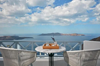
Firostefani stretches above Santorini’s west coast, where the settlement looks out towards the caldera and the volcanic islands. White houses and narrow passages follow the contours of the rock, and the view changes as you walk between homes and small churches. The neighbouring town of Fira offers more museums, transport links and evening options, while keeping you close to the caldera landscape.
The Megaro Gyzi Museum and the museums in Fira offer a glimpse into the island’s history and culture. The Archaeological Museum of Thera is approximately 680 m away, while Skaros, with the ruins of its medieval settlement on the rock, is a well-known walking destination. Fira Bus Station is 1.1 km away. Santorini Airport is 4.1 km away, and the ferry port is approximately 3 km from the area.
The walking route from Firostefani to Fira and then on to Oia follows the caldera, passing through a succession of settlements. Temperatures are often milder for walking in spring and autumn, while in summer it is worth setting off early or saving your exploration for the afternoon. In July and August, the meltemi winds affect the Cyclades; a light jacket is useful after sunset. For swimming, you can choose beaches elsewhere on the island and return later to enjoy the caldera light.
Skaros
— Rocky outcrop with the remains of a medieval settlement and walking trails.
900 m
Archaeological Museum of Thera
— Displays archaeological finds from Santorini and the surrounding area.
680 m
Megaro Gyzi Museum
— Museum in a historic mansion, with exhibits on the island’s history.
590 m
Museum of Prehistoric Thera
— Presents important finds from Santorini’s prehistoric settlements.
1.1 km
Exo Gialos Beach
— Coastal area on the eastern side of the island, near Fira.
2.7 km
Fira Bus Station
— Main station for services to settlements and beaches around Santorini.
1.1 km
 Ελληνικά
 English
 Deutsch
 Italiano
 Français
 Español
 Nederlands
 Polski







 Hotel

